


About Us
Executive Editor:Publishing house "Academy of Natural History"
Editorial Board:
Asgarov S. (Azerbaijan), Alakbarov M. (Azerbaijan), Aliev Z. (Azerbaijan), Babayev N. (Uzbekistan), Chiladze G. (Georgia), Datskovsky I. (Israel), Garbuz I. (Moldova), Gleizer S. (Germany), Ershina A. (Kazakhstan), Kobzev D. (Switzerland), Kohl O. (Germany), Ktshanyan M. (Armenia), Lande D. (Ukraine), Ledvanov M. (Russia), Makats V. (Ukraine), Miletic L. (Serbia), Moskovkin V. (Ukraine), Murzagaliyeva A. (Kazakhstan), Novikov A. (Ukraine), Rahimov R. (Uzbekistan), Romanchuk A. (Ukraine), Shamshiev B. (Kyrgyzstan), Usheva M. (Bulgaria), Vasileva M. (Bulgar).


Engineering
 PDF
PDFAbstract. This paper examines the use of geographic information systems from the perspective of the end user: the interactive map, obtaining the necessary information. The considered system Yandex.Maps and 2GIS.
Key words: geoinformational system, GIS, Internet GIS, the web server, 2GIS.
Internet GIS is a system that performs basic manipulation with spatial data on a dedicated web-map server and providing this data to users via the Internet Protocol compatible with HTTP [1].
Security Internet GIS depends largely on the security of the web server on which it is based [2].
If at the beginning the advent of the Internet (last century) and he himself, and, especially, geographic information systems, was inaccessible for the masses, then gradually, they became more and more popular. So, a large spread in the beginning of the XXI century received various interactive maps (Yandex.Maps, 2GIS, etc.) that are used when finding the route to a certain point, information about the object that is in a known location. Often used and additional features such as GIS: for example, you can find out which objects are close to the selected point, where there are objects with certain properties, etc.
For example, in planning a tourist trip it is possible to learn using GIS (or search engines on the Internet without GIS), what is the cost of the hotel rooms in the hotels of this locality. You can also plan your travel route, find out what attractions are within the route. In [8] an example of a geo-portal for tourism topics, created using geographic information systems.
Figure 1 shows a fragment of the resource Yandex.Maps marked with the locations of the museums.
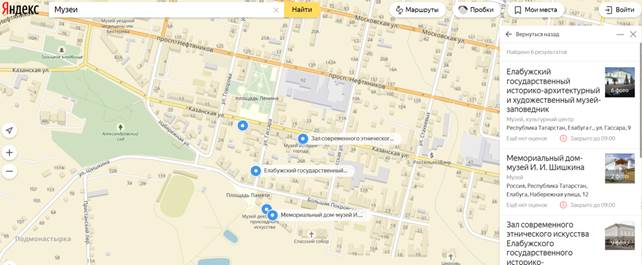
Figure 1. Museums on the resource Yandex.Maps
Convenient and other GIS functions: for example, we can know exactly where an Agency, its hours of operation and routes of travel by different modes of transport.
Figure 2 provides a window of 2GIS resource with information about the Museum and its location on the map.
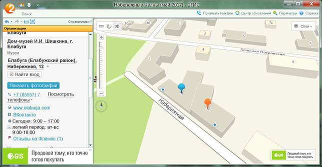
Figure 2. Information about the Museum on the resource 2GIS
Thus, the use of Internet GIS in their daily activities without the use of high-precision maps.
When you select a geographic information system it is necessary to consider the specific tasks that the user intends to solve with the help of this system. If the problem is rather complicated, it is advisable to develop your own version of the GIS, using the GIS in conjunction with it.
When using Internet-GIS should be borne in mind that the user requests can be stored in the system or transferred to third parties, so that when processing restricted information should not use public GIS, and ideally - do not use the Internet at all, and use only the internal network.
2. Mironova Yu.N. Geoinformacionnye sistemy i internet // Itogi Vserossijskoj nauchno-prakticheskoj konferencii «Professional'nye kommunikacii v nauchnoj srede — faktor obespechenija kachestva issledovanij». «Molodoj uchenyj» №9.1 (89.1), maj-1 2015 g., s. 40-42. URL: http://moluch.ru/archive/92/17769/
3. Mironova Yu.N. Geographic information systems and their classification // International Journal Of Applied And Fundamental Research. – 2016. – № 1 – URL: www.science-sd.com/463-24961 (26.04.2016).
4. Mironova Yu.N. Virtual modeling in geoinformation technologies // International Journal Of Applied And Fundamental Research. – 2016. – № 2 – URL: www.science-sd.com/464-24988 (09.08.2016).
5. Mironova Yu.N. The classification of geoinformation objects // International Journal Of Applied And Fundamental Research. – 2016. – № 2 – URL: www.science-sd.com/464-25151 (29.09.2016).
6. Mironova Yu.N. The study of geoinformatics with the use of gaming moments // International Journal Of Applied And Fundamental Research. – 2016. – № 3 – URL: www.science-sd.com/465-25000 (09.08.2016).
7. Mironova Yu.N. Geographic information systems and confidentiality of information // European Journal Of Natural History. - 2016. - № 5. С. 48-49. URL: www.world-science.ru/euro/519-33634 (01.09.2016).
8. Safarjan A.A. Turistskij geoportal kak instrument vizualizacii rezul'tatov issledovanija i prodvizhenija destinacii // Servis v Rossii i za rubezhom. 2016. T. 10. № 4 (65). S. 56-70.
9. Internet resurs «Geoinformatika. Pod redakciej prof. B.C. Tikunova. M.: «Akademija», 2005» http://www.studfiles.ru/preview/1817795/
Mironova Y.N. The use of consumers of Internet GIS. International Journal Of Applied And Fundamental Research. – 2017. – № 3 –
URL: www.science-sd.com/471-25218 (25.03.2026).