


About Us
Executive Editor:Publishing house "Academy of Natural History"
Editorial Board:
Asgarov S. (Azerbaijan), Alakbarov M. (Azerbaijan), Aliev Z. (Azerbaijan), Babayev N. (Uzbekistan), Chiladze G. (Georgia), Datskovsky I. (Israel), Garbuz I. (Moldova), Gleizer S. (Germany), Ershina A. (Kazakhstan), Kobzev D. (Switzerland), Kohl O. (Germany), Ktshanyan M. (Armenia), Lande D. (Ukraine), Ledvanov M. (Russia), Makats V. (Ukraine), Miletic L. (Serbia), Moskovkin V. (Ukraine), Murzagaliyeva A. (Kazakhstan), Novikov A. (Ukraine), Rahimov R. (Uzbekistan), Romanchuk A. (Ukraine), Shamshiev B. (Kyrgyzstan), Usheva M. (Bulgaria), Vasileva M. (Bulgar).


Biological sciences
 PDF
PDFHuman economic activities lead unavoidably to disturbance of the environmental state. A progressing global economic development involves in the anthropogenic cycle more and more areas of natural landscapes. Before the academic community, the objective is assigned not only to record the changes taking place in the landscape components but also to examine the mechanisms of new anthropogenic physico-chemical processes resulting in different transformations of natural systems. This will allow not only to monitor the changes in time of the state and features of the natural landscape components at various stages of the man-induced impact but also to perform the forecast of these changes for the future.
Sometimes, a situation occurs when, for one reason or another, the anthropogenic impact on the landscape stops. From the scientific standpoint, it is very interesting because the opportunity is afforded to study the stages, processes and rates of self-cleaning of landscape components and self-regeneration of the environment under natural conditions [4].
Such situation was created within the impact area of the lead smelter zone in Primorsky Krai. The study area is located on the Sea of Japan coast.
A detailed investigation of territory being subject to the impacts of the lead smelter emissions since 1929 was carried out in the 1975-77s. The key sites located at different distances from the emitter and differing in intensity of the technogenous impact were selected on the basis of the spatial distribution in the soil cover of major pollutants (lead, cadmium and zinc) [5]. The first key site was situated within a zone of maximum impact of technogenous emissions on the territory adjacent to the lead smelter. Here, the vegetation and upper humic soil horizons are fully destroyed. The surface looks like the technogenic desert. The second and third key sites were chosen within zones of the moderate and weak impacts. Morphological characteristics of all landscape components within these zones are satisfactorily expressed.
The first investigation of key sites was made in 1977 while the second one in 1989. Within this time interval, the smelter has operated with increasing volumes of production. The third study of key sites was performed in 1998. This time period is characterized by progressing stagnation of production. The fourth investigation was accomplished in 2012 after the enterprise operation was terminated some years ago. Differences in the enterprise operation resulted in differences in intensities of impacts of the technogenous emissions on the environment. In order to reveal the response of soils to dynamics of the impact in each key site, the randomized collection of soil samples was carried out [1]. The samples were taken at points of the square grid with the square side length of 4 m. In each key site, 30 samples were taken. Within zones of the weak and moderate technogenic impact of the third and second key sites, the samples of humic horizon of 0-2.5 cm thick were collected. Within a zone of maximum technogenic press of the first key site, the layer-by-layer, at depths of 0-2.5; 2.5-5.0 and 5-10 cm, sampling of eroded soils was performed. Every survey of soils and sample collection were carried out in the second half of July. For all samples, the acidity of soil, organic carbon content, total content of heavy metals and content of two mobile species of metals were determined.
The investigations accomplished according to such scheme agree closely with new paradigm of adaptive monitoring proposed by Lindenmayer D.B. and Likens G.E. [3].
This paper presents the statistically processed quantitative estimates of dynamics of the actual acidity of the surface 0 - 2.5-cm layer of eroded soils obtained over the whole period of observations from 1977 through 2012. A processing of the numerical information was made using computer program Statistica 6.
Acidity is one of the most important soil characteristics. The acidity determines the state of both mineral and organic soil components. The acidity controls the forms of chemical compounds in soils and their migratory capacity. In addition, it determines also, to a considerable degree, both the behavior of toxic matters of different genesis in the landscape and their capacity to be involved in the biological cycle and food chains. From this perspective, a carrying out of monitoring of the soil acidity is very important, especially, in the technogeneously disturbed landscapes.
The executed long-term monitoring of the acidity of eroded soils suggests the substantial changes in this index with time. The samples of empirical values of pH obtained in different years reflect the dynamics of this characteristic for different volumes of technogenic press on the soil covering and at the early stage of the natural recovery of landscape.
The pH values for the surface (0 – 2.5 cm) layer of soils measured in the course of their primary investigation in 1977 varied in the range of 3.82 to 4.21. When examining soils in 1989, the range of pH values fluctuations was 4.03 – 4.26. In the samples of 1998 and 2012, the pH values varied from 4.12 to 4.43 and from 4.27 to 4.73, respectively. The ranked empirical values of pH for each sample form the certain not coincident series (Fig. 1) confirming a presence of the long-term differences in soil acidity. It can be also seen that the acidity of eroded soils decreases consistently with time. Most noticeable lowering in soil acidity took place over the period of 1998 to 2012 which is undoubtedly related to lack of the acidifying effect of the technogenic emissions. The fact of reduction in soil acidity over the period of 1977 to 1989 was found to be interesting. The lead smelter has operated at full power and gas emissions have extended over the adjacent territory, however, there was an increase in pH values especially most noticeable within the range of low values. It can result from both erosion of the technogenic desert surface and vertical migration of acidic components.
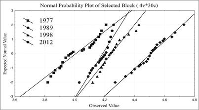
Fig.1. Normal probability plots of empirical values of pH in the soil samplings in various years of testing.
A character of the spatial heterogeneity of empirical values of pH was estimated using the Shapiro-Wilk (W) criterion [2]. The W values estimated for samples of 1977, 1989, 1998 and 2012 are equal to 0.928, 0.906, 0.948 and 0.979 respectively. Therefore, it is admissible to consider that the variability of pH complies with normal distribution law in the samples of 1977, 1998 and 2012 with с α >= 0.05 and in the sample of 1989 with α = 0.01 (W0.05; 30 = 0.927 and W0.01; 30 = 0.900).
The statistical characteristics calculated for all samples (Table 1) suggest also a reduction in acidity of eroded soils most noticeable after cessation of impact on them of technogenic emissions over the period of 1998 to 2012. In this case, the soil acidity decreased on 0.26 of pH units. The selective range of empirical values of pH varied from 0.39 in 1977 to 0.23 in 1989, to 0.31 in 1998 and to 0.46 in 2012. The interquartile range of pH value was 0.20 in 1977, 0.06 in 1989, 0.08 in 1998 and 0.09 pH units in 2012. The variation coefficients were equal to 3.0% in the sample of 1977, 1.4 % in the sample of 1989, 1.6 in the sample of 1998 and 2.2 % in the sample of 2012.
Table1. Statistical characteristics of acidity values for the surface layer of eroded soils in the samples of various years, n=30
|
Years |
Mean |
Median |
Min |
Max |
Variance |
Std. Dev. |
Stan dard |
25th% case |
75th% case |
|
1977 |
4,01 |
3,98 |
3,82 |
4,21 |
0,0134 |
0,12 |
0,02 |
3,92 |
4,12 |
|
1989 |
4,19 |
4,21 |
4,03 |
4,26 |
0,0030 |
0,06 |
0,01 |
4,16 |
4,22 |
|
1998 |
4,25 |
4,24 |
4,12 |
4,43 |
0,0052 |
0,07 |
0,01 |
4,20 |
4,28 |
|
2012 |
4,51 |
4,51 |
4,27 |
4,73 |
0,0099 |
0,10 |
0,02 |
4,46 |
4,55 |
The significance of differences of mean values in the empirical samples of pH was estimated using t-test for independent variables (Table 2). The obtained values of t proved to be notably higher than t0.05 = 2.05. Therefore, with a probability of more than 95 %, the differences of mean values between samples can be considered to be significant. The differences of variances were significant with α of 0.05 (F0.05 = 4.0) only between samples of 1977-1989. The differences of variances proved to be insignificant between samples of 1989-1998 and 1998-2012 with α of 0.05.
Table 2. Significance of differences in mean values and variances between the samples: n=30, df =58
|
Years |
Mean |
Mean |
t-value |
p |
Std.Dev. |
Std.Dev. |
F-ratio |
p |
|
1977 vs. 1989 |
4,01 |
4,19 |
-7,59 |
0,00 |
0,12 |
0,06 |
4,44 |
0,00 |
|
1989 vs. 1998 |
4,19 |
4,25 |
-3,57 |
0,00 |
0,06 |
0,07 |
1,71 |
0,16 |
|
1998 vs. 2012 |
4,25 |
4,51 |
-11,82 |
0,00 |
0,07 |
0,10 |
1,91 |
0,09 |
The comparative analysis of significance of differences by samples is vividly presented in diagrams (Fig. 2).
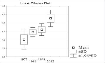
Fig. 2. Diagrams of mean pH values ranges in the samples of various years.
The diagrams suggest distinctly that the greatest differences of all statistical characteristics occur only between the samples of 1977 and 2012. For them, there are no any common values of variables. The samples of 1977 and 1989 differ significantly in means and pH values within the standard deviations. However, the expected values of pH from their confidential intervals can be equal. Between the samples of 1989 and 1998, the differences are only significant for mean values. The remaining intervals include the same for both samples values of pH. Differences between the samples of 1998 and 2012 are distinctly significant for mean values and pH values within the standard deviations. The pH values between the upper limit of the standard deviation and confidential interval of the 1998 sample coincide with those between the lower limit of the standard deviation and confidential interval of the 2012 sample.
The median values of the samples are close to values of the sampling means and they are the same in the 2012 sample. Diagrams of differences between medians (Fig. 3) reflect the same character of significance of differences by samples as was established for sampling means.
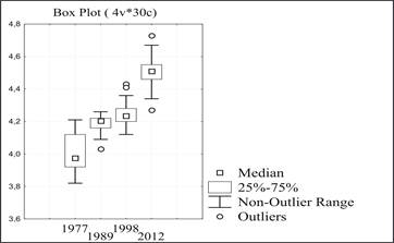
Fig. 3. Diagrams of median pH values ranges in the samples of various years.
CONCLUSION
A dynamics of the technogenically eroded soils acidity was investigated using the random samplings from surface soil layer in case of change in power of technogenic burden on the landscape and cessation of impact of man-made emissions. The spatial variation of empirical values of pH in all samples follows the normal distribution law. The differences in statistical characteristics of soil acidity in time are significant.
2. Dmitriev E.A. Matematicheskaya statistica v pochvovedenii: Uchebnic. M., Izd-vo MGU, 1995. 320 s. (Rus.)
3. Lindenmayer D.B., Likens G.E. Adaptive monitoring: a new paradigm for long-term research and monitoring // Trends in Ecology and Evolution. 2009. Vol. 24. No. 9. P. 482-486.
4. Makarevich R.A. Izmenenie landshaftnoj obstanovki i kislotnosti tehnogenno jerodirovannyh burozemov s prekrashheniem jemissij svincovogo proizvodstva // Jekologija i biologija pochv: Mater. mezhdunar. nauch. konf., Rostov-na-Donu, 17–19 nojabrja 2014 g. - / otv. red. Kazeev K. Sh. – Rostov-na-Donu: izd-vo Juzhnogo federal'nogo universiteta, 2014. S. 127-130. (Rus.)
5. Osnovnye problemy izuchenija i dobychi mineral'nogo syr'ja Dal'nevostochnogo jekonomicheskogo rajona. Mineral'no-syr'evoj kompleks DVJeR na rubezhe vekov /Ju.I. Bakulin, V.A. Burjak, E.N. Galichanin i dr. – Habarovsk, 1999. – 214 s. (Rus.)
Makarevich R.A. ADAPTIVE MONITORING OF THE TECHNOGENICALLY ERODED SOILS ACIDITY IN PRIMORSKY KRAI (RUSSIA). International Journal Of Applied And Fundamental Research. – 2016. – № 5 –
URL: www.science-sd.com/467-25080 (12.06.2026).